

Texas Property Water Profile
Built for the new TREC Form 61-0 - the Seller's Disclosure About Groundwater and Surface Water Rights - the Texas Property Water Profile provides groundwater records and property ownership behind any Texas property.
Whether you're a seller of Texas land or considering buying a Texas property, search by address, GPS coordinates, Property ID / APN, or well number and download one document: the Groundwater Conservation District, wells on record, ownership details, plus the area's well-success rates and a groundwater assessment drawn from our exclusive surveys and historical well records.
Street address·GPS coordinates·Property ID / APN·Well number
Rural addresses are often incomplete or shared across parcels. If you have the Property ID from the appraisal district or a well number off a report, you can search with that instead.

Sample Profile - contents shown for illustration.



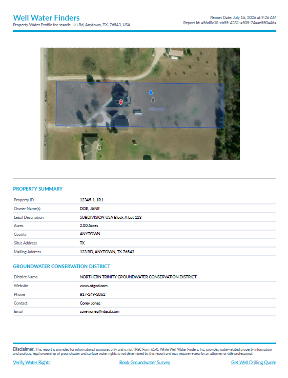
Property & public records
PART 1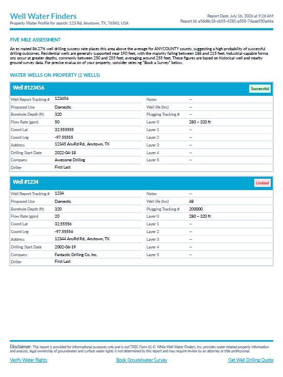
Groundwater intelligence
PART 2Built for TREC Form 61-0
NEW FOR 2026What TREC Form 61-0 Means When You Sell Texas Land
As of July 1, 2026, a new disclosure became part of selling property in Texas. TREC Form 61-0, the Seller's Disclosure About Groundwater and Surface Water Rights, asks sellers to share what they know about the water tied to a property: whether it sits inside a Groundwater Conservation District, whether it has water wells, and related groundwater and surface water details.
The Texas Property Water Profile gathers those groundwater records for any Texas property into one downloadable document in seconds. It gives you the facts to fill it out with confidence, and to hand a buyer something solid.
What's Inside the Texas Property Water Profile
One download for any Texas property, in two parts: the public records that help you answer the disclosure, and the groundwater intelligence behind the decision.
Property & Public Records
Property Identification
Property ID, legal description, county, and the property and mailing address. The Property ID that comes back is the same identifier you can search on next time.
Groundwater Conservation District
The district your property falls in, with its website and contact information.
Property Ownership
The ownership details on file for the property.
Wells on Record
Water wells documented for the property in public records.
Groundwater Intelligence
Area Well-Success Rates
How often nearby wells have come in successful, based on the area's drilling record.
Area Groundwater Assessment
A read on the area's groundwater patterns, drawn from our exclusive on-site surveys and historical well records.
How the Property Water Profile Works
Pay per property, no subscription - just a free account. Your Profile is ready to download the moment you search, and every one you order stays in your account, so the properties you've researched are all in one place.
Step 01
Find the property
Search by street address, GPS coordinates, Property ID / APN, or well number. Four ways in, so a missing or shared rural address doesn't stop you.
Step 02
Get your Profile
We pull the property records and area groundwater intelligence into one report, ready in seconds, not days.
Step 03
Download and share
Download the Profile to answer the disclosure's groundwater questions, share it with a buyer, or keep it for your records.
Step 04
Keep them in one place
Every Profile you order is saved to your account under My Property Water Profile Reports, with the property, the purchase date, and a download button for each.
How the Profile Helps You Answer TREC Form 61-0
The disclosure asks what you know about the property's water. The Texas Property Water Profile puts the records in front of you, question by question.
On the form
Is any portion of the property in a Groundwater Conservation District? If yes, name it and its website.
In your Profile
The district your property falls in, with its website and contact information ready to enter.
On the form
Are there water wells on the property?
In your Profile
The water wells documented for the property in public records, so you answer from the record.
On the form
Have the groundwater rights been severed, sold, or leased?
In your Profile
The current ownership of record, so you know whose name the property is in. Severance is traced through the deed record - see how to verify water rights.
Where to Go From Here
Your Profile gives you the records. Here's where to take them next.
Verify Water Rights
See how to confirm the property's groundwater and surface water rights, with the option to connect with an attorney.
Verify Water RightsBook a Groundwater Survey
Want ground-truth at a specific site? Book an on-site survey that measures groundwater and depth where you plan to drill.
Book a SurveyGet a Well Drilling Quote
Ready to drill? Connect with a well driller for a quote on the work.
Get Well Drilling QuoteWell Water Finders is a 2026 Global Top 50 Planet-First Innovation, recognized by the Sustainable Innovation Council.


FAQs
No. The Profile is an informational report that helps you answer the groundwater questions on the Seller's Disclosure About Groundwater and Surface Water Rights (TREC Form 61-0). It isn't the official form and doesn't replace it.
This is common with rural land. You can pull a Profile using GPS coordinates, the Property ID / APN from the county appraisal district, or a well number from a water well report. Any of the four inputs returns the same complete report.
Yes. The disclosure is the seller's responsibility, but the records inside the Profile are exactly what a buyer wants for due diligence: the groundwater district, wells on record, property ownership details, and the area's well-success patterns, all useful before the offer goes in.
Starting July 1, 2026, the disclosure becomes a standard part of most Texas property sales, though some transactions are exempt under state law. Whether the form applies to your sale is best confirmed with your agent or attorney. If you need help with the water rights themselves, our Verify Water Rights page can connect you with a water law attorney. The Profile gives you the groundwater records to answer the form when it does apply.
We count a well as successful when it delivers at least 5 gallons per minute and can provide water for 8 hours or more. Wells that produce water but can't sustain that combination are labeled "Limited." It's a stricter bar than informal definitions of success, applied the same way across the whole dataset.
The Profile's groundwater intelligence shows patterns from historical well outcomes and prior on-site surveys in the area. Drilling outcomes still depend on local geology, equipment, and pure local variation, so the data informs the decision rather than promising what a single point will hold.
The Profile is a desk report of records and area patterns for any Texas property. An on-site survey is a physical visit to a property using our patented groundwater detection equipment, which measures groundwater and depth at a specific site. Many people start with the Profile, then book a survey when they want ground-truth at a planned drilling spot.
The Profile is $24.99 per property, with no subscription required. However, paid map subscribers do receive a $5 discount on each profile ordered.
Yes. Every Profile you purchase stays in your account under My Property Water Profile Reports, listed with the property and the date you bought it, with a download button for each. Order several and they all appear there together, which is handy when you're working through a list of properties.
Across all 254 Texas counties, where our groundwater data is most comprehensive.
Buying or selling Texas land? Get ahead of the new water disclosure.
The Texas Property Water Profile puts the groundwater records behind any Texas property in your hands - searched by address, coordinates, Property ID / APN, or well number. Ready for TREC Form 61-0 if you're selling, ready for your due diligence if you're buying.
Get Your ProfileThis report is provided to assist with property water research and TREC Form 61-0 disclosures. Water rights ownership is not determined by this report and may require review by a qualified attorney or title professional.